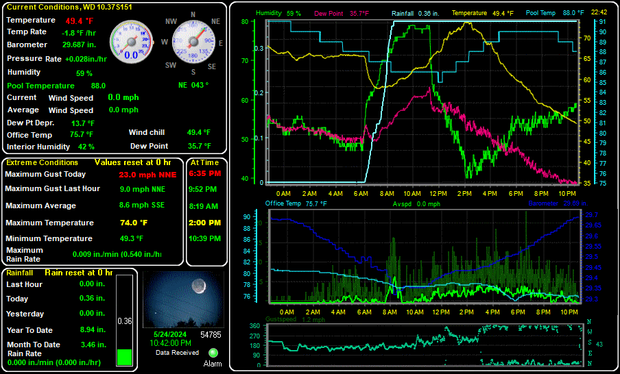
Last update: 09:32 AM - 3/31/2026. Next update: ---.
Current WX:Temp: 37.7 Max gst this hr: 6.0 - NE Windchill: 36.0 Today's Hi: 37.7 at 9:30 AM Today's Lo: 34.1 at 6:26 AM
 Sat & Radar
  Local Radar

Today Increasing clouds. lows in the upper 30s. north winds 5 to 15 mph.

Tuesday Cooler. mostly cloudy with a 20 percent chance of rain showers in the morning, then mostly sunny in the afternoon. highs in the lower 50s. north winds 10 to 15 mph.
Tuesday night Mostly cloudy. lows in the lower 30s. north winds 5 to 15 mph.

Wednesday Colder. mostly cloudy. a 30 percent chance of snow showers and rain showers in the afternoon. highs in the lower 40s. east winds 5 to 15 mph.
Wednesday night Snow showers and rain showers likely in the evening, then snow showers after midnight. light snow accumulations. lows in the lower 30s. east winds 10 to 15 mph. chance of precipitation 80 percent.

Thursday Snow showers. light snow accumulations. highs in the upper 30s. chance of snow 90 percent.

Thursday night Mostly cloudy. snow showers and chance of rain showers in the evening, then chance of snow showers after midnight. lows in the upper 20s. chance of precipitation 90 percent.

Friday Partly sunny. chance of rain showers in the afternoon. highs in the lower 40s. chance of showers 40 percent.